WALKING | Hayfield to Kinder Downfall 14.6km Circular Peak District Walk

Walk Details
Kinder Downfall from Hayfield, circular route, see it here.
- Hard/challenging
- 14.6km / 9 miles
- 695m
- 7.26 Hours


On Friday evening we leave work, and in less than an hour we’re pulling up at Hayfield Campsite in the High Peak. I’ve been wanting to walk Kinder Scout since reading a friends blog article about it the year before, though it’s taken until now to get chance. The last time we were in the region visiting Mam Tor, the weather was horrendous with extremely low visibility, so I’m hoping the forecast weather holds.

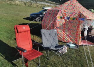
We arrive at the campsite to find my daughter and her boyfriend are already there and pitched. Our pitch is right beside them, and with our reduced weekend camping set up, we’re ready to relax with a G&T about 45 minutes later. We make dinner and then sit together looking at the stars and full moon, listening to owls hoot, discussing the route we’re planning to take tomorrow.

Heading to Bowden Bridge carpark across the road from Hayfield campsite
We wake up early on Saturday to bright sunshine. I get breakfast on the go for the 4 of us, then we set about packing our backpacks ready for the days walk. I’d chosen the campsite due to it’s proximity to the start of the route we plan to follow, and after a hearty breakfast and checking we’ve all got water and supplies for the day, we set off.

Leaving the campsite we walk across the road to the starting point of the walk, where we pause to look at the sign commemorating the Mass Trespass of 1932, when walkers joined forces to defend their right to ramble.

We check the route again, set our various GPS tracking devices and head off towards the first section of the walk that takes us up past Kinder Reservoir.

The first part of the walk leading to Kinder Reservoir
As we walk, the sun climbs higher and as we start to gain height our pace slows. More of the beautiful landscape reveals itself, providing some stunning photo opportunities.

The first climb, with Kinder Reservoir on our right

The view over the wall as we start to gain height

Higher up now, we have a clear view of Kinder Reservoir

Green algae in the water

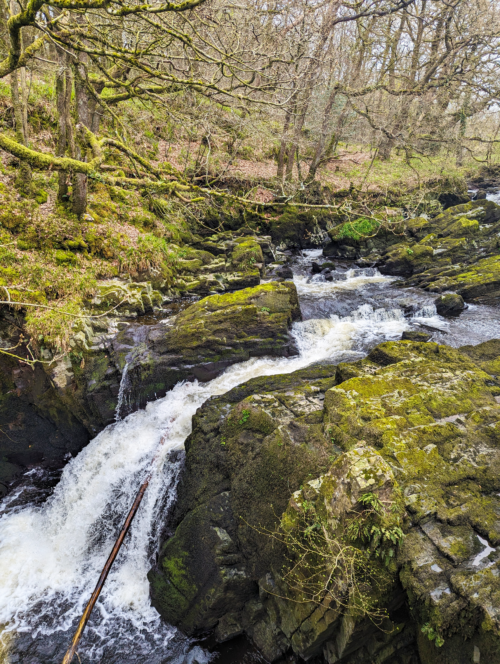
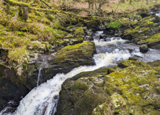
The far end of the reservoir, with Kinder Downfall clearly visible


We take frequent stops to take photographs and catch our breath. Once we clear the reservoir, heather lines the path as we make our way towards the next climb which takes us up the side of stream. The terrain starts to get rocky as we continue up via William Clough to reach the plateau of Kinder Scout.

The view back down to the reservoir
 A cairn up on the Kinder Scout plateau

The rocks around Kinder Downfall


The weather remains on our side, and we stop when we reach Kinder Downfall for a long lunch, sunbathing and more photographs.

Red Brook, and more stunning photo opportunities

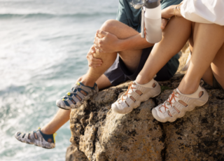
Daughter Shammie and her boyfriend Josh

One of the reasons why our walks always take so long – stopping at every opportunity to take photos!

Probably the coolest picture I took on the walk

High up at the Kinder Scout Trig point
Another stop to check the final part of the route
We stop near Eadale Cross to check the GPS to make sure we are still on the right route, and to make sure we can find our way back down into Hayfield.

We head back down to Hayfield and immediately make a beeline for the Sportsman Inn where we enjoy an enormous meal. The food is excellent and after over 6 hours of walking, we’re delighted to get a proper breather before making our way back to the campsite for a well earned shower.

From open water swimming, snowboarding and kayaking to hill walks and meditation, Shell shares her travels and microadventures here on the blog and in various publications she's written for, Shell has a particular interest in promoting wellbeing and the many benefits of nature therapy.
- WELLBEING | Witches Whispers From Routin Brig Waterfall, Scotland - April 25, 2024
- TRAVEL | The Little Coffee Bag Co. Delicious Coffee On The Go – Review - April 16, 2024
- NEWS | Easy Glamping With Easy Camp New Moonlight Spire Tipi Tent - April 15, 2024
Shop related products

Andes 4 Person Man Berth Double Skin Camping/Festival Dome Tent
£49.99 (as of April 25, 2024 19:17 GMT +01:00 - More infoProduct prices and availability are accurate as of the date/time indicated and are subject to change. Any price and availability information displayed on [relevant Amazon Site(s), as applicable] at the time of purchase will apply to the purchase of this product.)
Portal 3-4 Man Tent with Porch, Camping Tent for 3 to 4 Persons with Sewn-in Gro...
£99.99 (as of April 25, 2024 19:17 GMT +01:00 - More infoProduct prices and availability are accurate as of the date/time indicated and are subject to change. Any price and availability information displayed on [relevant Amazon Site(s), as applicable] at the time of purchase will apply to the purchase of this product.)
Lifemaison Camping Tent Automatic 3-4 Man Person Instant Tent Pop Up Dome Tent,4...
£19.99 (as of April 25, 2024 19:17 GMT +01:00 - More infoProduct prices and availability are accurate as of the date/time indicated and are subject to change. Any price and availability information displayed on [relevant Amazon Site(s), as applicable] at the time of purchase will apply to the purchase of this product.)
Coleman Tent Darwin, Compact Dome Tent, also Ideal for Camping in the Garden, Li...
£95.83 (as of April 25, 2024 19:17 GMT +01:00 - More infoProduct prices and availability are accurate as of the date/time indicated and are subject to change. Any price and availability information displayed on [relevant Amazon Site(s), as applicable] at the time of purchase will apply to the purchase of this product.)
PUREBOX Camping Tent for S(1-2)/L(2-3) Person, Dome Tent, Easy Set Up Lightweigh...
£39.99 (as of April 25, 2024 19:17 GMT +01:00 - More infoProduct prices and availability are accurate as of the date/time indicated and are subject to change. Any price and availability information displayed on [relevant Amazon Site(s), as applicable] at the time of purchase will apply to the purchase of this product.)
Milestone Camping Dome Tents
£24.99 (as of April 25, 2024 19:17 GMT +01:00 - More infoProduct prices and availability are accurate as of the date/time indicated and are subject to change. Any price and availability information displayed on [relevant Amazon Site(s), as applicable] at the time of purchase will apply to the purchase of this product.)
Eurohike Sendero 4 Tent for 4 People with Porch and Living Area, 4 Man, Easy to ...
£99.00 (as of April 25, 2024 19:17 GMT +01:00 - More infoProduct prices and availability are accurate as of the date/time indicated and are subject to change. Any price and availability information displayed on [relevant Amazon Site(s), as applicable] at the time of purchase will apply to the purchase of this product.)


![CAMPING | Here’s How To Stay Warm In Your Tent – Warm Camping Tips [Updated 2024]](https://www.campingwithstyle.co.uk/wp-content/uploads/2024/02/shell0816_photorealistic_realistic_photo_of_the_inside_of_a_c_dd26c3c4-c779-4081-85b0-72e66a81b03b_1-320x230.png)
![GEAR | The Best Warm Sleeping Bags For Spring Camping Trips [Updated March 2024]](https://www.campingwithstyle.co.uk/wp-content/uploads/2024/02/10-best-warm-sleeping-bags-2024-320x230.png)