WALKING | Top 20 Walking Locations in Cumbria from Ordnance Survey
We’re loving the new data visualisations and league tables of the most popular walking routes in the UK from Ordnance Survey.
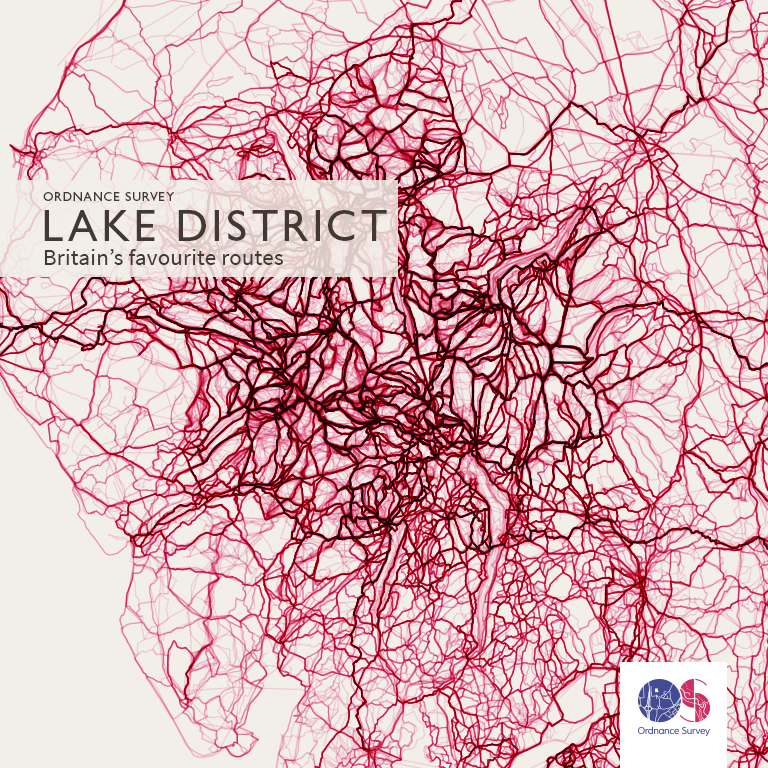
The new league tables of favourite British routes are compiled from 10 years of routing data from Ordnance Survey’s digital outdoor products, and It’s not too surprising to learn that of the most popular walking routes in the UK, the Lake District is top of the list.
The analysis of over half a million routes reveals just how highly revered the Lake District is. Eighteen of the top twenty most popular places to create a route fall in the heart of the Lake District National Park, close to popular tourist locations Keswick, Ambleside, Grasmere, Helvellyn and Scafell Pike. The other two top twenty places are in Snowdonia.
OS has also produced a league table of the most popular towns and cities where people like to create routes. Again the Lake District prevails with Keswick and Ambleside topping the table, clearly ahead of nearest rivals Guildford and the City of Westminster. See below for the full tables.
Nick Giles, Managing Director of Ordnance Survey Leisure, says: “For centuries the Lakes have held a special place in people’s hearts, and we know the area is loved by map users, because the region frequently tops our bestselling paper maps. However, when we started examining this data and looking at the route-creating habits of people we weren’t expecting the Lake District to dominate so strongly. We live in such a spectacular and varied country, so if you can’t make it to the Lakes you could try exploring your own county. As in life the less well travelled paths can be the most rewarding.”
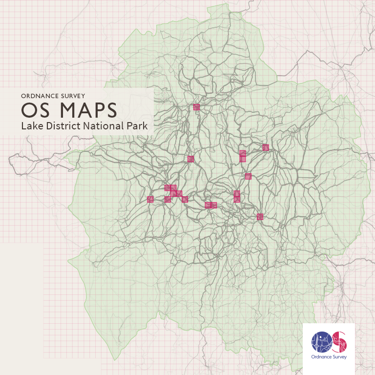
OS Route Data Visualisations
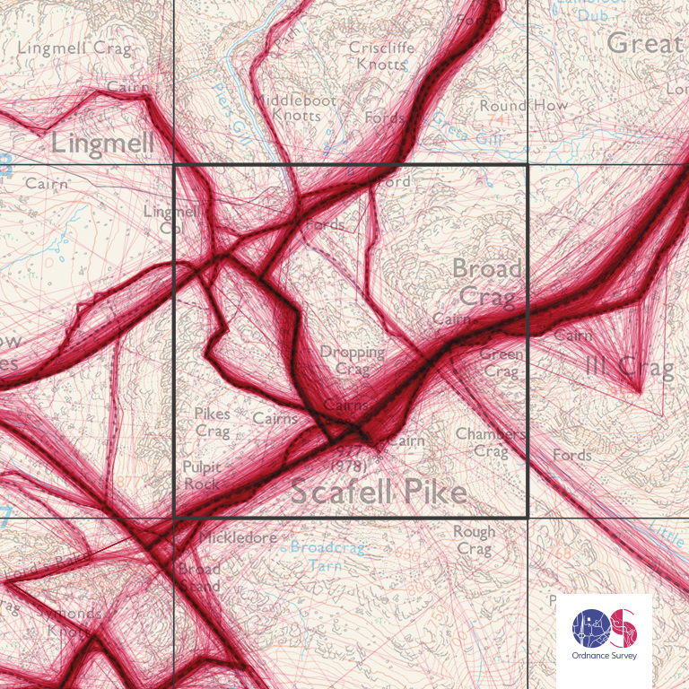
There are 500,000 plus routes that have been illustrated in a series of stunning data visualisations created by OS cartographer Charley Glynn. Also responsible for taking the look of digital mapping to the next level with his design for the recent app release OS Maps, Charley said: “What I find amazing is that the people who have created these routes for their outside adventures have logged almost every bit of British coastline, neatly framing the rest of the data and giving the illusion you are looking at a map of Great Britain. The darker, thicker areas illustrate the higher concentration of routes and reveal popularity.
Top 20 locations (by 1km grid square) and number of routes
- OSGB GridRef: NY2107 – Scafell Pike Summit – 2172
- OSGB GridRef: SH6054 – Snowdon Summit – 2111
- OSGB GridRef: NY2308 – Allen Crags (Near Scafell Pike) – 1918
- OSGB GridRef: NY2208 – Great End (Near Scafell Pike) – 1908
- OSGB GridRef: NY2806 – Langdale Fell (Cumbria Way) – 1865
- OSGB GridRef: NY3415 – Helvellyn Summit – 1793
- OSGB GridRef: SD8072 – Horton in Ribblesdale – 1593
- OSGB GridRef: NY2514 – Rosthwaite – 1576
- OSGB GridRef: NY3308 – Grasmere (North) – 1558
- OSGB GridRef: NY1807 – Wast Water (North) – 1551
- OSGB GridRef: NY2623 – Keswick – 1539
- OSGB GridRef: NY2407 – Rossett Pike (Near Scafell Pike) – 1531
- OSGB GridRef: NY3414 – Nethermost Pike (Near Helvellyn) – 1527
- OSGB GridRef: NY3704 – Ambleside – 1520
- OSGB GridRef: NY3816 – Glenridding – 1519
- OSGB GridRef: NY2209 – Great Slack (Near Scafell Pike) – 1515
- OSGB GridRef: NY2906 – Langdale Fell (Cumbria Way) – 1491
- OSGB GridRef: NY3511 – Fairfield Summit – 1487
- OSGB GridRef: NY3307 – Grasmere (Centre) – 1467
- OSGB GridRef: NY2109 – Sty Head (Near Scafell Pike) – 1431
Visit the Ordnance Survey website here.
Have you walked any of the top 20 routes or are you planning to? Let us know in the comments below, we’d love to hear from you!

From open water swimming, snowboarding and kayaking to hill walks and meditation, Shell shares her travels and microadventures here on the blog and in various publications she's written for, Shell has a particular interest in promoting wellbeing and the many benefits of nature therapy.
Shop related products

Coleman Tent Octagon, 6 Man Festival Dome Tent, 6 Person Family Camping Tent wit...
£144.95 (as of April 23, 2024 19:17 GMT +01:00 - More infoProduct prices and availability are accurate as of the date/time indicated and are subject to change. Any price and availability information displayed on [relevant Amazon Site(s), as applicable] at the time of purchase will apply to the purchase of this product.)
Coleman Tent Darwin, Compact Dome Tent, also Ideal for Camping in the Garden, Li...
£94.84 (as of April 23, 2024 19:17 GMT +01:00 - More infoProduct prices and availability are accurate as of the date/time indicated and are subject to change. Any price and availability information displayed on [relevant Amazon Site(s), as applicable] at the time of purchase will apply to the purchase of this product.)
Night Cat Camping Tent for 1 2 Person Man Waterproof Backpacking Tents Easy Setu...
£47.49 (as of April 23, 2024 19:17 GMT +01:00 - More infoProduct prices and availability are accurate as of the date/time indicated and are subject to change. Any price and availability information displayed on [relevant Amazon Site(s), as applicable] at the time of purchase will apply to the purchase of this product.)
Cflity Camping Tent, 3 Man Instant Pop Up Tent Waterproof Three Layer Automatic ...
£89.99 (as of April 23, 2024 19:17 GMT +01:00 - More infoProduct prices and availability are accurate as of the date/time indicated and are subject to change. Any price and availability information displayed on [relevant Amazon Site(s), as applicable] at the time of purchase will apply to the purchase of this product.)
Berghaus Adhara 500 Nightfall Tent for 5 People with Darkened Bedrooms, Separate...
£249.00 (as of April 23, 2024 19:17 GMT +01:00 - More infoProduct prices and availability are accurate as of the date/time indicated and are subject to change. Any price and availability information displayed on [relevant Amazon Site(s), as applicable] at the time of purchase will apply to the purchase of this product.)
XJYMCOM Dome Tents Pop Up Camping Tent Automatic Camp 2-3 Person Canopy Lightwei...
£24.99 (as of April 23, 2024 19:17 GMT +01:00 - More infoProduct prices and availability are accurate as of the date/time indicated and are subject to change. Any price and availability information displayed on [relevant Amazon Site(s), as applicable] at the time of purchase will apply to the purchase of this product.)
Andes 4 Person Man Berth Double Skin Camping/Festival Dome Tent
£49.99 (as of April 23, 2024 19:17 GMT +01:00 - More infoProduct prices and availability are accurate as of the date/time indicated and are subject to change. Any price and availability information displayed on [relevant Amazon Site(s), as applicable] at the time of purchase will apply to the purchase of this product.)


![CAMPING | Here’s How To Stay Warm In Your Tent – Warm Camping Tips [Updated 2024]](https://www.campingwithstyle.co.uk/wp-content/uploads/2024/02/shell0816_photorealistic_realistic_photo_of_the_inside_of_a_c_dd26c3c4-c779-4081-85b0-72e66a81b03b_1-320x230.png)

![GEAR | The Best Warm Sleeping Bags For Spring Camping Trips [Updated March 2024]](https://www.campingwithstyle.co.uk/wp-content/uploads/2024/02/10-best-warm-sleeping-bags-2024-320x230.png)